

Guide to Long Beach and the Salakphet area
2025 – 26 Update
✔ Amazing views and a hair-raising drive on Koh Chang’s most scenic road
✔ See what will eventually be a huge Buddha statue over looking the bay
✔ Probably the most picturesque area of the island but the beach is remote
In this corner of Koh Chang you’ll find some of the best views the island has to offer; great seafood; a fishing community; undeveloped beaches; a couple of waterfalls; excellent jungle trekking; a historic temple and mangrove walkway.
Salakphet Bay encompasses all of south east Koh Chang. Both the east and western banks of the bay have very different highlights. If you’re already been to Salakkok then it’s easiest to continue down the road on the eastern side of the bay before heading back the way you came in order to get over to the western shore and Salakphet and Rong Thian villages.
This road runs from Salakkok through the usual tropical countryside for another 3-4Km, ending at the hamlet of Ban Jek Bae. This is home to a few small resorts the majority of which cater to Thai package tourists travelling on ‘3 day 2 night’ tours which will include a snorkelling trip, an hour canoeing in the bay and a disproportionate amount of time spent eating copious amounts of seafood and uploading photos of themselves doing it to Facebook & Tiktok.
Parama Resort is the best in this area of the island. Very nice 4 star rooms in a small resort which features a large sea water aquarium surrounding the main building. Good fun to watch the turtles and all manner of fish swimming around at breakfast. No beach here but they do rent the beach on a nearby island in the bay and provide a free boat service for guests.
There’s also a very nice little resort ‘Karang Bay View’ down the track at the end of this road. It has a good restaurant and a small beach with some excellent views across the bay. Good spot for lunch.
Another place nearby that’s worth a stop if you need refreshment or are looking for some peace and quiet is the English/Thai run Journey’s End has a handful of bungalows and caters for guests looking to unwind away from city life. The owners also run regular fishing and snorkelling trips to the outlying islands.
Long Beach
The reason many tourists come down here is to try to get to Long beach. After passing Jek Bae hamlet, there’s a turning on the left. There’s a small sign for Long Beach Resort and a larger one for kayak hire and boat trips to Koh Ngam. A small shack on the corner, Rainbow Happy House, sells food, drinks and gasoline, so fill up here if you’re running low on any of these.
The road to Long Beach, which until late 2016 was a stony dirt track has been paved and so getting there by car isn’t an issue. What was a slow, bumpy but leisurely, scooter ride is now become a race to the beach.
Not necessarily a good thing as having a bad road meant speeds were low and accidents few. However the effects of a few rainy seasons are beginning to show and each year the road deteriorates in places due to subsidence and small landslides. So care is required in some places where subsidence and/or landslides have occured.
The road to Long beach is as spectacular as ever though. It offers some of the best views on the island.
Once you get on the road the 7 kilometre long rollercoaster ride begins as its path hugs the side of a hill above the shoreline. With the sun shining and a clear view out to sea and back to inland Koh Chang it’s a great trip for anyone who appreciates spectacular scenery.

The best place to stop to admire the views is at a viewpoint about 1 Km before the concrete road ends. You can park at a small National Park office. You can buy gasoline for your motorbike and get a cold beer or soft drink here.
There’s a rickety shelter on the cliff top which has great views to the islands south of Koh Chang. The nearest islands are Koh Laoya and Koh Wai and behind them you can see part of Koh Kood. On a clear day Koh Kood will also be visible. The rocks nearby, by the flagpole, provide a great location for panoramic views across Salakphet Bay to the mountainous inland of Koh Chang. (That’s where the photo above was take from.)
Further along the road there’s another spot for postcard views – looking along the coastline and into the bay. Nearby, virtually hidden by trees is a small concrete staircase was built to take people to the top of the hill where there’s yet another viewpoint. However, this has been neglected for years so it’s unlikely you’ll get any views. But worth checking in case it does get cleared, as it was built to provide another opportunity to look towards the islands to the south.
On the way here, you’ll have noticed how the road is deteriorating. And you may also have noticed the concrete drainage ditch which lies alongside the road has been inlaid with small stones. This was all done by hand and makes you wonder about whether this work should have taken priority over the completion of the road itself. (I remember driving along here when construction was still underway, around 2003, and seeing dozens of workers sitting by the roadside pressing stones into wet concrete in order to beautify the ineffectual drainage ditch.)

Needless to say, at present there’s nowhere to stop and eat & no toilets etc unless you call in at the Treehouse. The Treehouse has been in a cycle of opening for 4-5 months in High Season and closing for the rest of the year. The huts are very basic – just an old mattress, threadbare mosquito net and single lightbulb. You can’t expect too much for 200 – 300 Baht / night nowadays.
It is an excellent spot to take a break, have a swim and a cold fruit shake and can get busy – as virtually everyone heading down this way will access the beach here and many stop for lunch.
On the hillside above, an ugly concrete hotel block, ‘Long Beach Resort’ was completed in 2016 but never seems to be open. It’s locked up and and the area around it is now an abandoned construction sites. It will be interesting to see who will actually stay here.
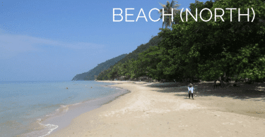
Long Beach itself is a 400 metre long crescent of palm fringed sand. A stunning, peaceful location with untouched jungle clad hillside as a backdrop. You can imagine it being home to an exclusive luxury resort in the future – especially as the land is owned by one of the largest companies in Thailand. Head to the far southern end of the beach for the best photo looking along the lenght of the beach and the mountains behind.
Perfect . . . not quite. The elephant in the room is the garbage on the beach.
The bay is very sheltered and during the rainy season a lot of plastic is washed up. It accumulates around the high tide line under the trees and , stays there until there is an annual beach cleanup. The garbage isn’t from Koh Chang, look closely and you’ll see bottles and plastic food wrappers from various SE Asian countries which end up in the Gulf of Thailand.
Map of Salakphet and Long Beach
This is just the highlights to help familiarize yourself with the area.
History Lesson
The road ends a few hundred metres south of Long Beach. Just before you reach the end you come to at a 40 metre long strip of beach known as ‘Had Yuthanavy’. The sole reason for building the road was to get visitors to visit this spot as offshore is the location of the wreck of a Thai naval ship which sank during the defeat by the French Navy in 1941. In 2018 a new memorial – in the shape of a large concrete ship – was constructed. This is occasionally used by visiting dignitaries as an air-conditioned shelter from the heat but apart from that is closed.
‘The Battle of Koh Chang’ is a textbook example of how to plan and execute a naval attack. Unfortunately, for the Thai forces, it was the French that attacked them.
Having sailed down from Vietnam and ambushed the Thai navy. The whole battle was over in a couple of hours before breakfast. The end result was that the cream of the Thai navy was wiped out in one morning.
The Thonburi, which sank just off Hat Yuthanavy was originally put out of action some distance away but finally sank here after an attempt to tow it back to the mainland failed. You might see it listed as a wreck dive but in reality it is rarely, if ever, dived as the visibility is too poor to see anything and the wreck itself has now virtually disintegrated.
A little further on, at the far southernmost tip of Koh Chang, there now stands the remains of Sea Breeze restaurant (It closed many years ago and is now the site of a kayak rental place.) This used to do a nice line in basic Thai food, fresh from the sea seafood and fruit shakes. It was owned by a Thai / Vietnamese couple. She came here on a boat as a refugee.
In the late 1980s many Vietnamese boat people tried to make it to Thailand. However, the Thai government didn’t like this idea and so carte blanche was given to local fisherman to do whatever they liked in order to prevent the boats making it to the mainland. This push back policy resulted in refugee boats being rammed and sunk or refugees being dumped on rocky outcrops with no food or water. Such as the small islands just off Salakkok Bay.
The United Nations knew what was going on but observers weren’t permitted to enter the area for a couple of weeks after the first reports of bodies being washed ashore were made public. This is the sort of local history you won’t get any locals talking about. But it’d be fascinating to know what really went on here around 40 years ago.
The small island off the southern tip of Koh Chang is Koh Ngam, it also had one resort, Analay Resort, which is now closed and used as accommodation for National Park staff.
If you want to visit Koh Ngam, just rent a kayak from Tantawan Resort or the kayak rental place just south of Hat Yuthanavy for 200 Baht. It’s only a 10 – 15 minute paddle.
In the past there wasn’t an entry fee to the island. But as its popularity has grown, the National Park has now imposed a 200 Baht entry fee to visit the island. This is collected when you step foot on the island.
Tantawan Resort, on the opposite side of the bay, is an odd place. This was originally a handful of basic fisherman’s shacks which were torn down and rebuilt 15 years ago but has never properly opened. Although it is open and you can stay there for around 3,000 Baht/night. But it’s just not advertised anywhere.
It is worth a look around, they’ll be someone on hand to show you the rooms and you can get a drink and have some basic Thai food in the restaurant. The rooms are very nice inside. They feature glass floors and a bathtub with views out to the ocean.
It’s now time to head back the way you came and rejoining the main road before heading around to the west coast of the bay.
Salakphet Village
As with Bangbao, Salakphet is a fishing village. Unlike Bangbao every trace of local life hasn’t been destroyed and replaced with dive shops, seafood restaurants and souvenir stalls. Sure there are a couple of seafood places and numerous homestays plus a small yacht marina. But that’s pretty much the extent of commercialization round these parts.
The homestays, are very popular with young Thai groups who head to Koh Chang for a budget holiday. They are interested in a weekend of seafood and snorkelling, playing ‘Hotel California’ on an acoustic guitar and drinking copious amounts of Sang Som rum & coke. All before crashing out, eight people to a room on floormats laid out under mozzie screens in an old fisherman’s house.
It’s a different way to holiday compared to most western tourists, which is why you won’t find these homestays on Booking.com and you won’t see signs in English, only in Thai language by the roadside.
Salakphet itself is both the name for this area of the island and of one single village. The land at the head of the bay is all mangroves. From Salakphet village you can rent kayaks to explore this area. By road you only see half the village, most of the life is lining the canals in the mangroves. The village of Salakphet was until 20 years ago, a thriving fishing port. This was Koh Chang’s commercial centre but times change and it is now a rather sleepy fishing village. However, you’ll still some large wooden fishing trawlers moored up at piers in Rong Thian village, nearer the mouth of the bay, and smaller boats tied up outside locals houses.
To get to the main area of the village, ignore the well signposted right turn towards Salakphet Seafood and continue straight. Follow the road past the temple and continue slowly along the single track concrete road. There are a couple of places to stop for a drink here. And, if you are in the area longer and feel the need to get a tattoo, check out the work done by Panisa at Inki Tattoo Art Studio which is in the vicinity.
A little further along the road you’ll come the probably the best place to stay in the area – Mangrove Hideaway – is located in the village. Stop at the ice factory 100 metres south of Mangrove Hideaway and walk out onto the concrete walkway by the side of the canal where you’ll see fishing boats tied up and can get some nice photos opportunities.
At the front there is a walkway where you can see fishing boats and some local life. Back on the road again and you’ll eventually reach a small bridge that can only be crossed by foot or motorbike, there’s not much else down there apart from a couple more homestays and couple of good restaurants.
Fisherman’s Hut and Saengsawang Homestay are both good places by the sea for a drink or lunch. The former is more western orientated with extensive menu of European and Thai dishes. The latter is run by a middle aged local couple and is more homely and disorganised – which gives it a certain charm.
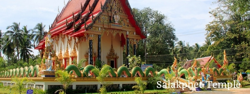
As you pass by the temple in Salakphet you’ll probably stop to take a quick photo. But instead of just snapping the exterior, go inside. A mural, which took two local artists over a year to complete was finished in 2012. This covers the entire interior walls of the temple. A very impressive piece of work. You have to pay a 20 Baht entrance fee , which goes towards the upkeep of the temple, but it’s well worth it.
You should also check out the small building near the temple – which looks like a mini temple and that’s exactly what it is. It’s the original, 140 year old temple building. This is now a small museum. It’s not always open. But if it is, take a look inside.
The murals inside tell the story of King Rama V who visited and stayed in the village during his reign. There’s also one of his old walking canes on display and a few other curios and artifacts including an ancient diving helmet.
Outside the temple are a handful of fruit shake & coffee shops where you can get a refreshing drink for 40-50 Baht.
The Red Bridge
A very interesting detour on the way through the village is the mangrove walkway. It’s another popular spot for ‘influencers’ to tick off their Koh Chang list.
As you pass the temple, you’ll notice a paved road leading off to the left. Just follow the signs for the Red Bridge, which is the mangrove boardwalk. In 2019 the access road was paved and the walkway renovated. ( The boardwalk is scheduled for another renovation in late 2025. Renovations in Thailand tend not to last very long. Renovating things is a good business to be in.)
On the way you’ll pass Nanai Resort, one of the best boutique guesthouses on the island. Originally built as a huge private home, the owners have turned it into a lovely home from home. They also brew their own craft beer.
There’s a parking area and small coffeeshop is located near the entrance. Pay 20 Baht to park at the coffeeshop. Also at the entrance is an old, disused information office and toilet block. Don’t use it, there’s no water.
It’s from this walkway that you get one of my favourite views on Koh Chang. This is of the sea of green about half way along the walkway. You turn a corner and just get an awesome view across the mangroves to the hills in the distance. Different hues of green in all directions. The walkway continues to the head of the bay. Photos of the renovated walkway back in 2019 here if you’re interested.

Having done the walkway and headed back to the temple, you can pass through through Salakphet village, you’re now on the road to the village of Baan Rong Thian on the west coast of the bay. The road meanders along for a few km, passes the start of the still incomplete road to Bangbao, and terminates in the car park of a restaurant called Salakphet Seafood.
Along the way you’ll see signs for a few small resorts and homestays. It’s also worth following a couple of the narrow concrete roads that lead off the main road to the left as these will take you to small fishing hamlets which are worth 10 minutes of your time to check out.
Also take a note of the garbage lying by the side of the road. You probably won’t see much. Now compare this to the west coast where you are bound to have seen and probably smelt piles of garbage and unemptied bins by the roadside near your hotel.
Why the difference?
Simple, the locals here keep their village clean whereas on the west coast most of the Thais aren’t locals and so there isn’t the sense of communal responsibility. Also pay attention to the verges at the side of the road, in many areas around Salakphet these have been planted with flowers and bushes which make the roadside far more attractive than any you’ll find on the garbage strewn west coast roads. This is done by the local government, they have been planting flowering bushes along the roadsides for many years.

Waterfalls & Views
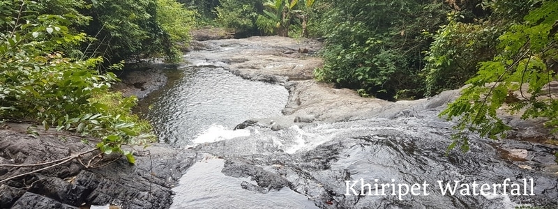
On the way down to Salakphet you’ll see signs for a couple of waterfalls – ‘Klong Neung’ and ‘Khiriphet’. Both have lovely narrow paved roads leading up to the entrance to the falls, the kind of small lanes that are really scenic. They are only a couple of kilometers in length but pass some locals’ houses, through fruit and coconut fields and end abruptly at the start of paths into the jungle.
Klong Neung is worth the effort, but it’s a real hassle to get to. So very few people bother.
There’s no obvious path, and you will have to walk along the river bed and scramble up rocks to get there. It is Koh Chang’s tallest waterfall – approx. 120 metres high. This cascades into a narrow gulley where you can swim. Very beautiful and eerily quiet. Although the pool is nowhere as big as that at, say Klong Plu or Kai Bae waterfalls on the west coast. But if you fancy an adventure then here are photos and a quick guide on getting to Koh Chang’s tallest waterfall.
Khiriphet waterfall is a walk of a similar length but is much easier, the path ends at an easy to reach fall where you’ll see a couple of plunge pools – big enough to cool off in and swim a little. It’s possible to climb to higher levels but again the path isn’t easy to clamber up. However, if you’re in the area then this waterfall is a good detour. Note that entrance to both these falls is free – there are no National Park staff stationed here, although you will notice the remnants of old offices and toilet blocks.
The road to Klong Neung also passes the turning for Altitude 79. One of the island’s best coffeeshops. It’s a basic open sided gazebo on a hillside with amazing views across the bay. There’s no electricity so coffee is made slowly using a hand made, portable Aram espresso maker that uses no electricity. The Thai owner had it made to order in Brazil and sent to Thailand. And it does make great coffee. There’s a limited menu here but try the iced espresso and orange juice. Truly delicious. Then sit back and enjoy the views and the silence. If you’re lucky you might also be able to see hornbills in the trees on the hillside.
Talking of hornbills, in the nearby valley you’ll find Hornbill Camp. A campsite set up specifically for people interested seeing hornbills. But it’s more set up for visiting Thai groups and families who will arrive with vehicles laden down with cooking equipment rather than backpackers on a budget.
Rong Thian
Although the bay and rea are known as Salakphet. The fishing community where the road ends is called Rong Thian. There’s no reason for you to remember this.
So, back to the useful stuff . . . The road ends in the car park of Salakphet Seafood Resort & Restaurant. Walk out onto the small pier at the restaurant. You’ll see dozens of keep nets with all sizes and varieties of fishes and be treated to 180 degree panoramic views, from the mountains inland, across the bay and out to the islands to the south. Koh Laoya and Koh Wai are easily visible from here.
There’s also a footpath from the car park that leads behind the fisherman’s houses that line the bay for another kilometre further down the shore. If you are into sailing, take this path and wander down to Island View pier. Here you’ll find yachts belonging to Gulf Charters and private owners. Rooms on the pier or in apartments overlooking the bay, are also available.
Head to the end of the path and you’ll come across Aoy’s Little Farm & Bakery. One of those hidden gems that actually is a hidden gem. Aoy & Erik have a small cafe which originally sold homemade cakes and coffee but has now expanded to include simple dishes. Many of which use ingredients grown in their organic garden. Definitely worth a stop, especially for anyone with a sweet tooth.
The islands in the bay can easily be visited by kayak, rent one at Island View or one of the seafood restaurants in the area.
Koh Phrao Nok, the southernmost of the three islands in the bay, is home to a rundown resort that is now deserted. It’s very interesting to wander around the crumbling ‘Ghost Resort’ which gets few visitors. Sai Khao Resort was built in the 80s and sold in the early 2000s to a large Thai conglomerate which owns lots of land on Koh Chang. It was then abandoned. There’s also a very nice little white sand beach on the island. (The far more popular and easily accessible ‘Ghost Ship‘ in Bangbao is a mecca for Youtubers. But the haven’t discovered this old resort yet. )
If you have already decided, before you arrive on Koh Chang, that you want to stay in Salakphet, then it is possible to take a songtaew from the centre of Trat town on the mainland. A small blue pick-up truck taxi heads to Salakphet thrice daily. Catch it at 10.30am, 12pm or 3pm from Trat temple.
White Buddha Viewpoint
Finally, if you’re looking for an awesome view to round off your time exploring you need to head up to the monastery close to Salakphet Seafood. It’s here that Koh Chang’s largest man made attraction is slowly being constructed. A giant Buddha statue will be built overlooking the bay.
When it is completed it will be a huge draw for tourists. Most likely it’ll be the main attraction on the island. But as it is financed by donations, progress is rather slow. At present, late 2025, the three level base of the statue has been completed. Some metal framework for the statue has been erected. But work on the actual statue itself has yet to start. So far it has taken 10+ years to get to this stage.
But it’s possible to go there, and go up the levels of the base and get the most amazing views across the bay. Entrance is free. But bear in mind it’s a religious site, please dress appropriately.
There are some photos in the gallery below of the views. The entrance to the monastery is about 400 metres before you reach Salakphet Seafood carpark on the sharp left hand bend. Turn in and just follow the paved road uphill for 200 metres.


Hotels in Salakphet
These resorts and bungalows are located around Salakphet bay and are bookable on booking.com. The price shown is a typical high season nightly rate. It may well vary and expect it to be higher at holiday weekends and during peak season.
Journey’s End Homestay– Just six bungalows and a laid back bar and restaurant set in a garden by the shore of Salakphet Bay. Run by Englishwoman, Nicky and her staff, a laid back place to de-stress and enjoy great view across the bay. From around 800 Baht
Sleepover Hostel. Clean and comfortable air-con dormitory beds in this new hostel in Salakphet village. Beds from around 300 Baht/night
Island View – AC rooms and a pool. Ideal for sailors as their private pier is used by yachtsmen – 1,200 Baht
Parama Resort – The best 4* in the area. Now has a new mid-price annex – 2,700 Baht
Salakphet Resort – Located at the popular Salakphet Seafood restaurant. AC bungalows built on stilts over the bay – 1,600 Baht
Baan Chan Lay Homestay – Basic aircon bungalows by the water in the fishing village. Ideal for observing local life – 1,200 Baht
Nanai Resort – Excellent luxury riverside guesthouse with pool – 3,000
Mangrove Hideaway – One of the top rated luxury guesthouses on the island. Waterfront location in the village – 2,500 Baht